Product Information
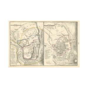
This antique map is by Joseph Meyer and titled Jerusalem. The map dates to the early 20th century and displays the street plan of Jerusalem with street building explanations. From Meyers Grobes Konversations-Lexikon. The map was published in 1905 in Leipzig and Wien by Joseph Meyers Bibliographic Institute Leipzig und Wien.
Dimensions
The sheet measure 6.25 x 9.25 inches.
Condition
The sheet displays mounting tape and pencil notations. The paper shows signs of toning and unevenly trimmed edges.