Product Information
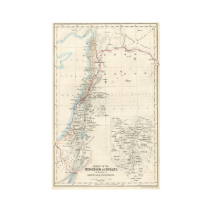
Journeyings of the Israelites from Egypt to Canaan. 19th-century map of the middle east and Israel, Engraved by Edw A. Gover, Princes St. Bedford Row Holy Land Map. Edw Gover compiled the map. Gover practiced during the early-mid 19th century and also is recorded to have completed Illustrations of the Books of Kings & Chronicles and the Captivities.
This black and white map of Israel, the middle east, and the holy land features hand-colored accents and includes the Red Sea, Lebanon, Mouths of the Nile, Israel, Arabia, Gaza, and many other important cities, geographies, and landmarks. The map is presumably dating to 1852 or the early 1850s.
Dimensions
The sheet measures 9.75 x 6.25 inches.
Condition
The sheet displays toning and mounting tape residue on the sheet’s edges. The sheet displays light creasing in the margin edges.