Product Information
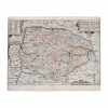
Maps are a great way to add decoration from the old world to your wall art decor. Shop this old English map by Christopher Saxton and William Kip sculpfit, detailing a portion of Norfolk England and dated 1637 on All The Decor. Entitled Norfolciae Comitatus Quem Oli, this hand color engraved map is well detailed and displays the area and surroundings in detail. Map maker Saxton was a famed English cartographer known for his first county maps of Wales and England.
This map is an excellent period example of hand-colored engraved maps of the 17th century. It adds value to any wall art decor interior when you’re looking for an old-world inspiration.
Dimensions
The sheet measures 12 inches by 15.5 inches.
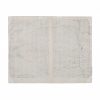
Condition
The map had been trimmed on the margin edges, with creasing and light toning and staining. Some areas of minor loss are also visible on the margins. The reverse of the map has been restabilized on the edges with mounting tape.