Product Information
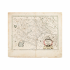
Shop this Jan Jansson Western Europe antique map for sale. This antique map dates to the 17th century and is inscribed “Dvcatvs Gelriae pars Tertia Quce est Comitatvs Zvtphaniensis.” The map details the region around the city of Zutphen in the historic Guelders and the Gelderland. The map includes hand-colored elements in the map legend and geographical areas. Jan Jansson also known as Johannes Janssonius, was born in Arnhem, Netherlands, dedicated his life to creating comprehensive maps and studies of the known world.
Dimensions
The sheet measures 9.75 inches by 23.75 inches; The image measures 14.75 inches by 20.25 inches.
Condition
The sheet and surface have areas of loss and repair, the original map backed on acid-free museum quality backing. The paper displays wear of wear, worm damage, foxing, and toning, all consistent with the age of this item.