Product Information
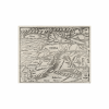
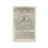
Discover this Holy Land map by German cartographer Sebastian Munster. This 16th-century map is entitled De Terra Sancta – The Holy Lands. The black and white map includes Syria, Cyprus, Palestine, Arabia, and Babylonia. The map was published circa 1550 and marked 1160, the page number of the old atlas. This map part of researcher Karrow R.W.’s book “Mapmakers of the Sixteenth Century and Their Maps.” This important map of the hold lands by a leading 16th-century map maker is a wonderful addition to any collection.
Dimensions
11 inches by 7.10 inches. The map measures 4.75 inches by 6.10 inches.
Condition
The map with light creasing and mounting table residue on the corner edges of the double-sided sheet.